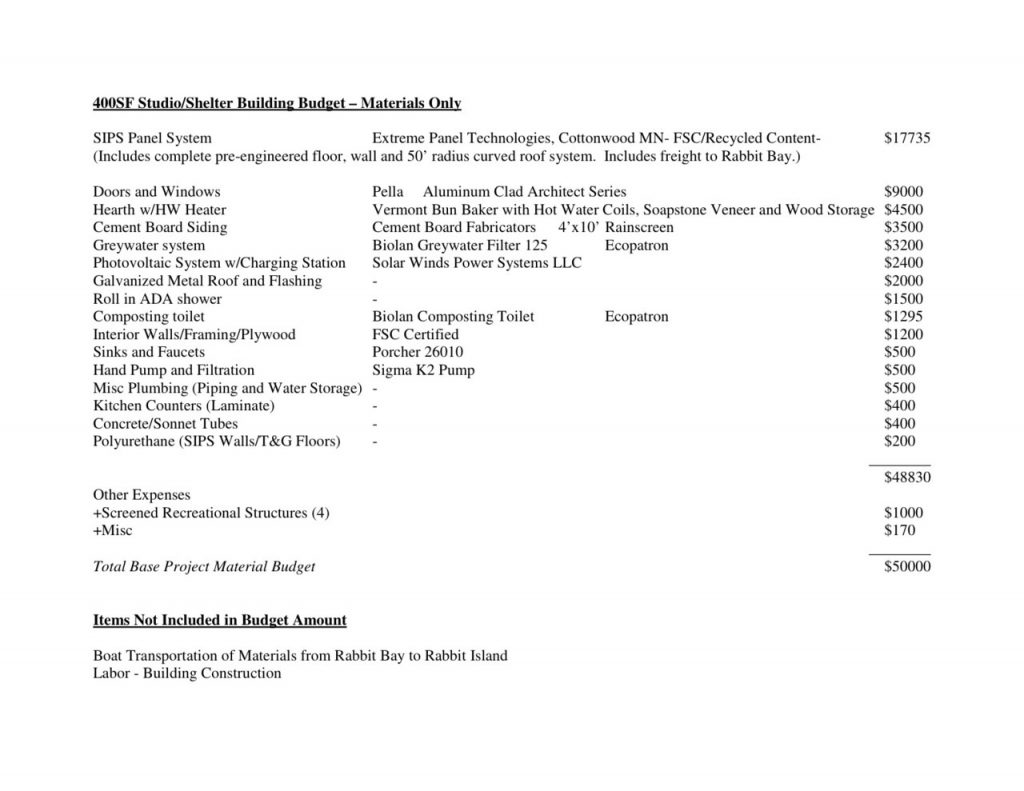
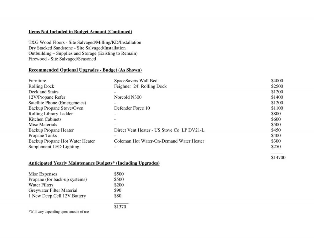
Rabbit Island Architecture Competition – Jury Duty
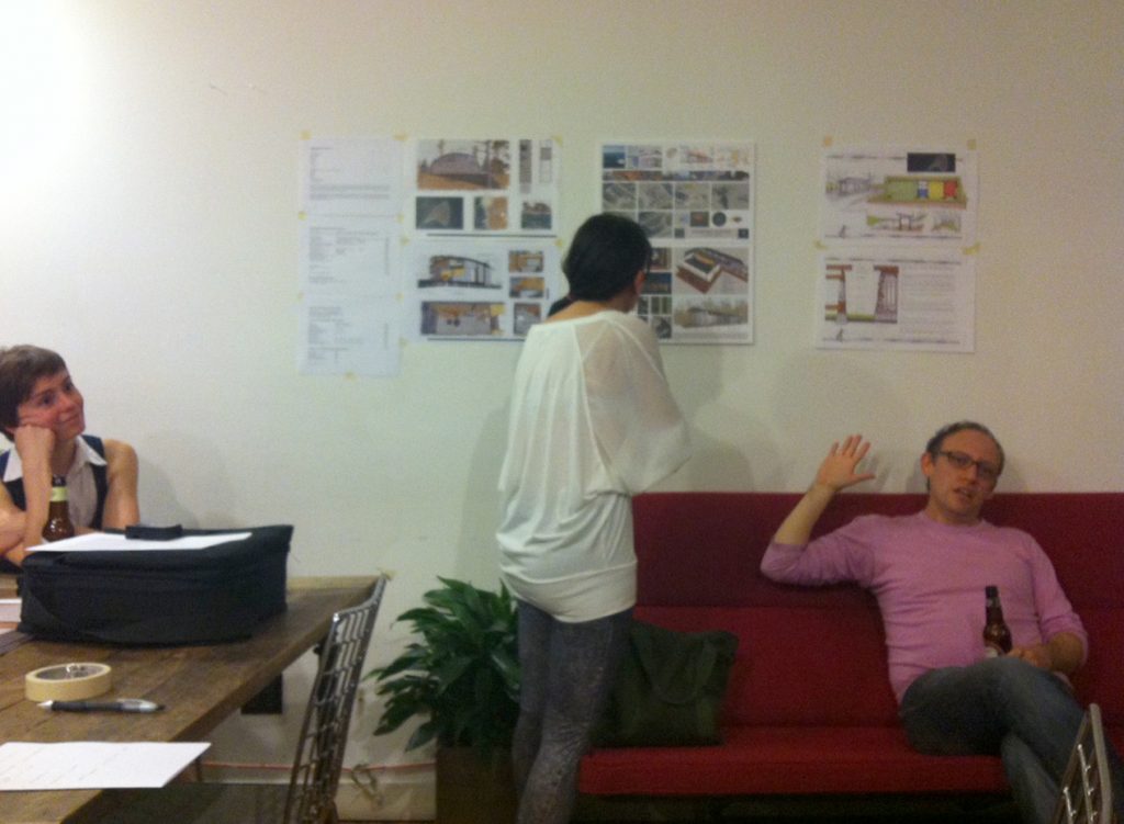
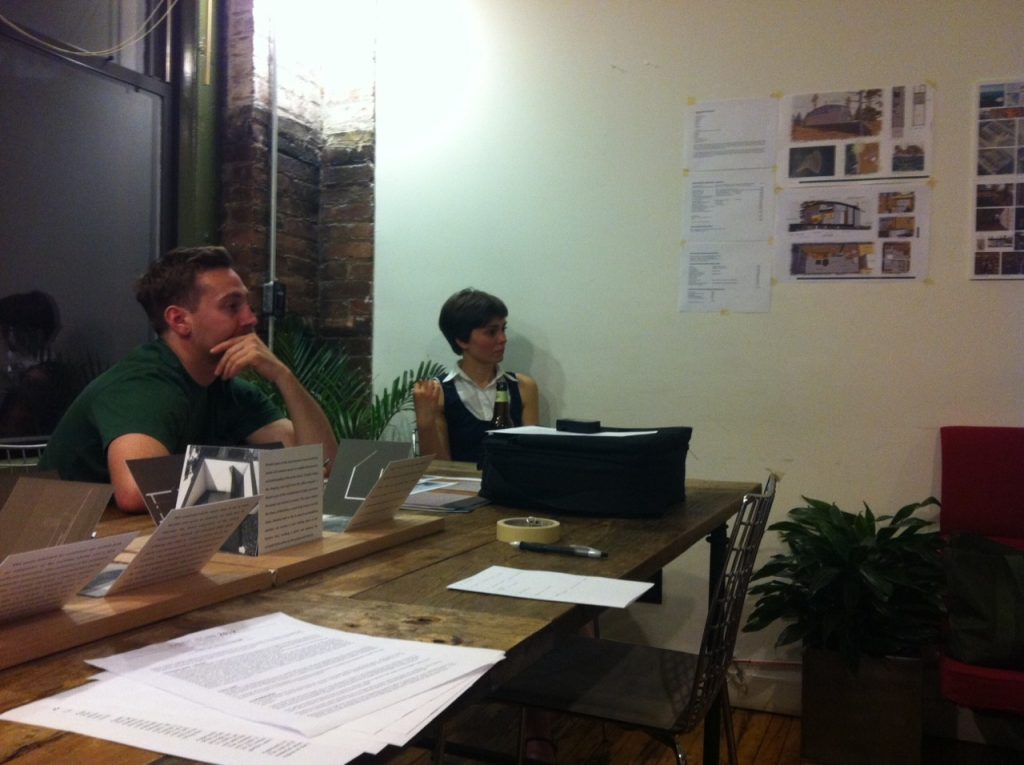
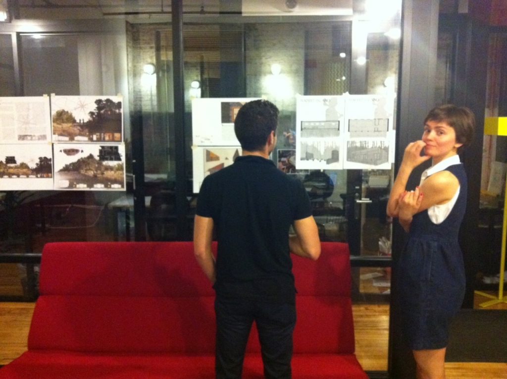
A jury of architects, designers and artists was assembled and began formal criticism of submissions to the Rabbit Island Architecture Competition this past Monday evening. We gathered in a conference room at the WeWork space in Soho and held a lively round-robin discussion. Seven submissions were received in total spanning a wide variety of conceptual references, technical complexity and philosophical tone. Out-of-town jurors are continuing to review submissions and will be summarizing their ideas which will then be added to the consensus of the NYC based meeting.
For reference the original competition guidelines can be found here.
Chris, architect
Monica, architect
Max, designer
Tom, artist
Jimmy, assistant professor of architecture at Copper Union
Melissa, director of the DeVos Art Museum
Leo, partner at LoT Architecture
Amanda, graphic designer at MoMa
Jace, editor of Cabin Porn
Julia, architect
Andrew, artist
Phil, artist and co-founder of Livestream
We will be basing our decision on the objective merits of each proposal alone, while attempting to avoid outside influence. However, as is the case with any jury, we may discover that there is no such thing as an impermeable media curtain. Thus feel free to add bias by ‘liking’ submissions on our blog or facebook page. We hope to have conclusions prepared by next Wednesday.
Submissions are linked here (in no particular order) and can also be found by scrolling through our blog: one + two + three + four + five + six + seven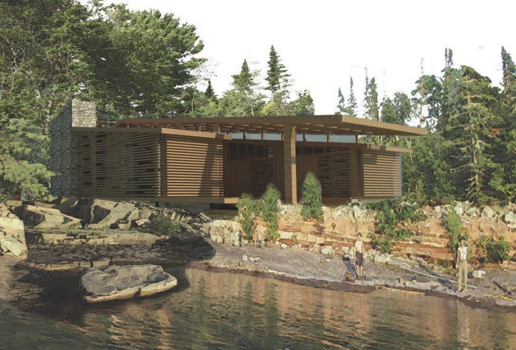
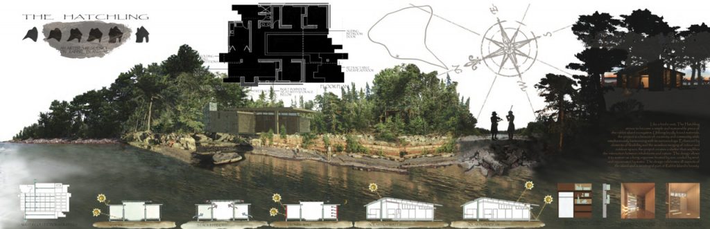
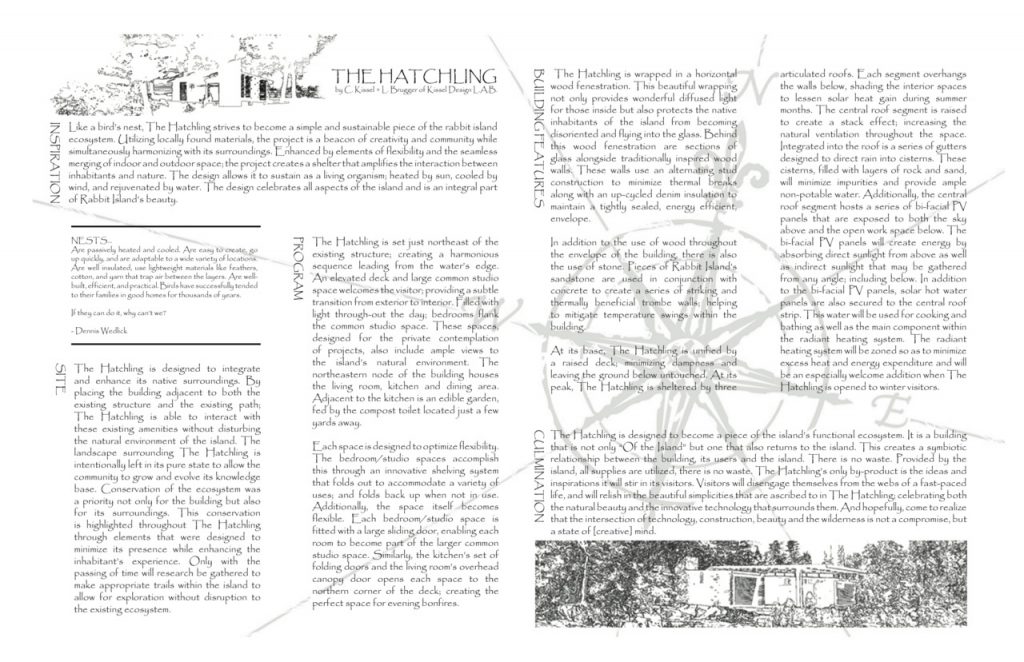
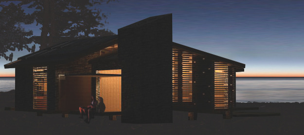
Rabbit Island Architecture Competition: the Hatchling
Submitted by Lindsay Brugger and Christina Kissel
“The Kissel Design LAB was born out of a desire to create innovative and contextually sustainable solutions that enhance the lives of all; believing that it is only through the inseparable qualities of purpose and place that a building becomes part of life’s evolving fabric.”
contact: lbrugger096@gmail.com, cmjkissel@gmail.com
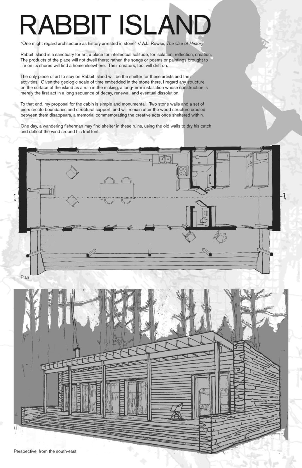
Rabbit Island Architecture Competition: Will Holman
Contact: objectguerilla.blogspot.com
“One might regard architecture as history arrested in stone.” // A.L. Rowse, The Use of History
Rabbit Island is a sanctuary for art, a place for intellectual solitude, for isolation, reflection, creation. The products of the place will not dwell there; rather, the songs or poems or paintings brought to life on its shores will find a home elsewhere. Their creators, too, will drift on.
The only piece of art to stay on Rabbit Island will be the shelter for these artists and their activities. Given the geologic scale of time embedded in teh stone there, I regard any structure on the surface of the island as a ruin in the making, a long-term installation whose construction is merely the first act in a long sequence of decay, renewal, and eventual dissolution.
To that end, my proposal for the cabin is simple and monumental. Two stone walls and a set of piers create boundaries and structural support, and will remain after the wood structure cradled between them disappears, a memorial commemorating the creative acts that once sheltered within.
One day, a wandering fisherman may find shelter in these ruins, using the old walls to dry his catch and deflect the wind around his frail tent.
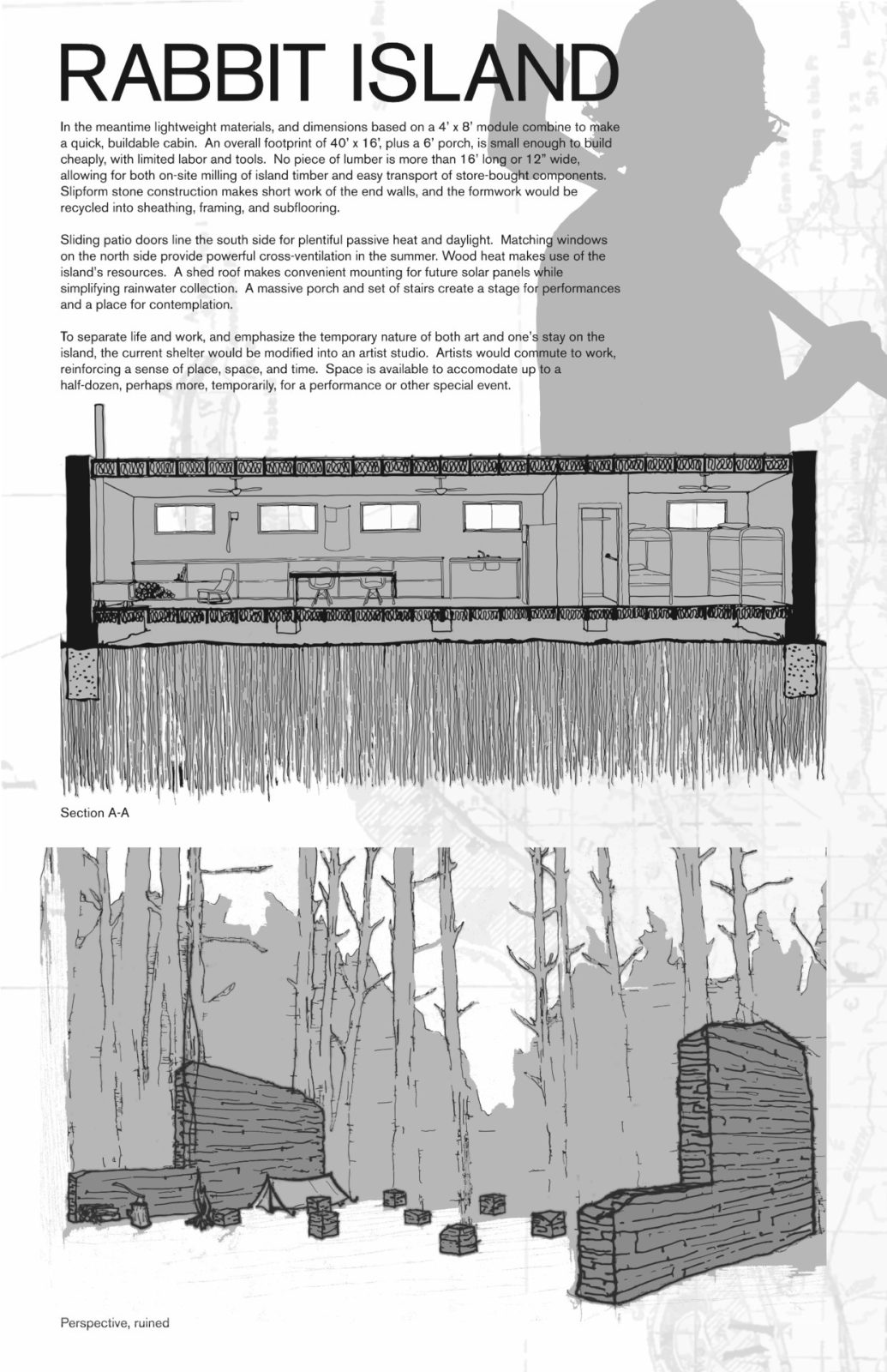
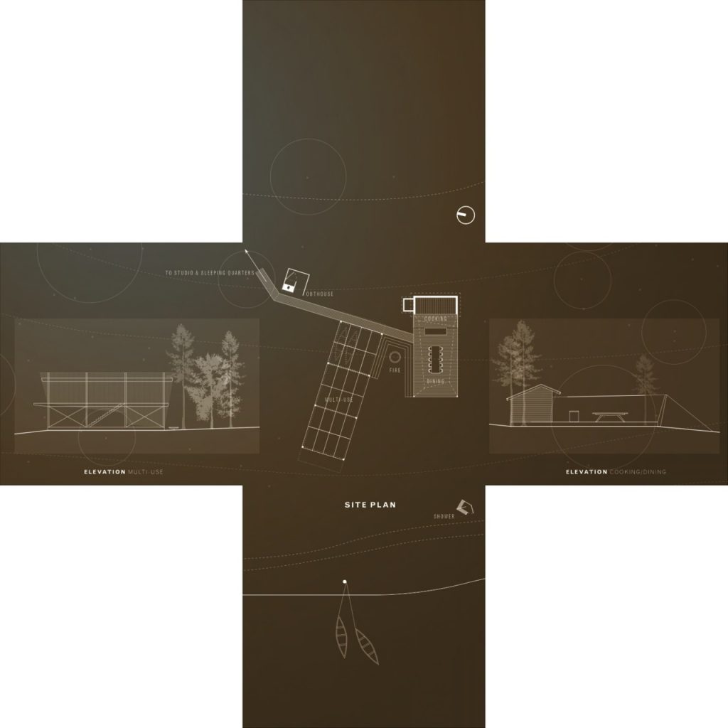
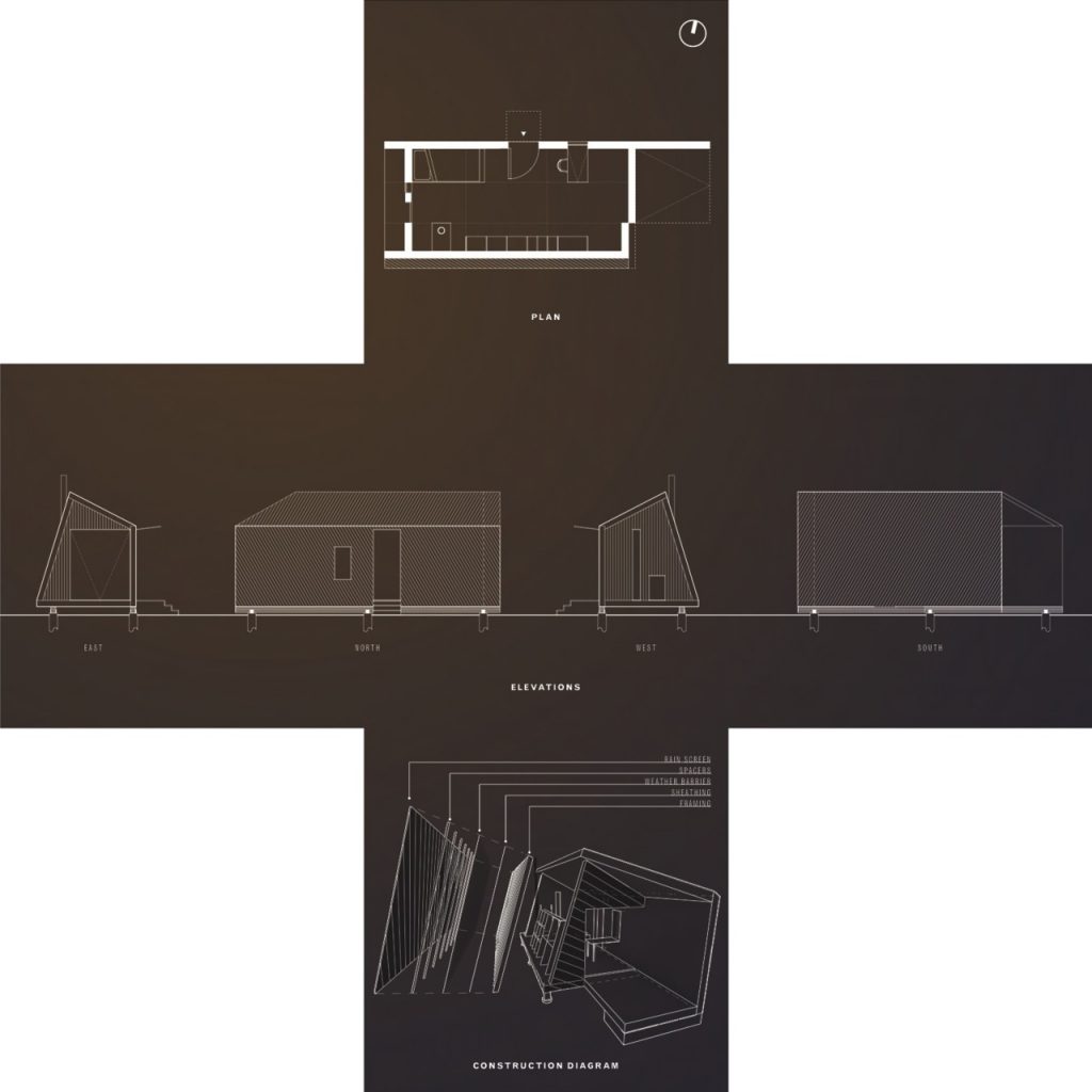
In the meantime lightweight materials, and dimensions based on at 4’ x 8’ module combine to make a quick, buildable cabin. An overall footprint of 40’ x 16’, plus a 6’ porch, is small enough to build cheaply, with limited labor and tools. No piece of lumber is more than 16’ long or 12’’ wide, allowing for both on-site milling of island timber and easy transport of store-bought components. Slipform stone construction makes short work of the end walls, and the formwork would be recycled into sheathing, framing, and subflooring.
Sliding patio doors line the south side for plentiful passive heat and daylight. Matching windows on the north side provide powerful cross-ventilation in the summer. Wood heat makes use of the island’s resources. A shed roof makes convenient mounting for future solar panels while simplifying rainwater collection. A masive porch and set of stairs create a stage for performances and a place for contemplation.
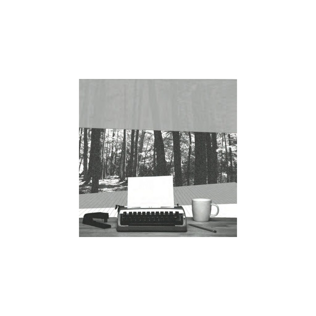
To separate life and work, and to emphasize the temporary nature of both art and one’s stay on the island, the current shelter would be modified into an artist studio. Artists would commute to work, reinforcing a sense of place, space, and time. Space is available to accommodate up to a half-dozen, perhaps more, temporarily, for a performance or other special event.
Rabbit Island Architecture Competition: A collaboration of Hatchback and Northerly Design Studios
Contact:
Jono Sturt: jbsturt@gmail.com
Thomas Affeldt
Rabbit Island makes legible a curious entanglement of technology, mass and culture. The challenges associated with arriving at (let alone building on) this small, remote and uninhabited island force any would-be inhabitant to make a shift in their customary priorities.
Technology / Mass
For the sake of contemporary building techniques, the absence of modern infrastructure (electricity, hardware stores, saw mills, roads, etc.) on the island effectively locates it in a separate place on the historical timeline. One cannot approach this project as if it were a contemporary suburban home; the technology that makes those buildings possible is simply not present.
Geography compounds this challenge, limiting the weight of what can be brought to the island via boat, and forces a shift in priorities, away from that of a typical project.
The metaphor of an umbilical cord– stretching from our present, all the way back to a time before places had names– seems apt here. An umbilical, only able to carry a small amount of to an unborn child, carries only what is the most valuable, nutritious, vital. So too must the building materials and practices for this site be considered; light, local, and low-tech wherever possible. To be clear, this is not an argument for a vernacular, nostalgic, or log-cabin-esque approach but rather an ambition of lightness, of flexibility, of decisions carefully made. This is not the frontier of westward American expansion, but it is a unique opportunity to address a similar context, given the advantages of a modern, globalized world.
Culture
The island’s remoteness has cultural ramifications as well as pragmatic ones. Any person or group of people spending a length of time in this place will likely come to develop a deeper, richer understanding of concepts such as solitude, presence of a place, the relationship of culture to nature… the list goes on.
To design structures responsibly for this island requires one to consider that whatever is built here will frame the occupants’ experience of being in this place.
Experience
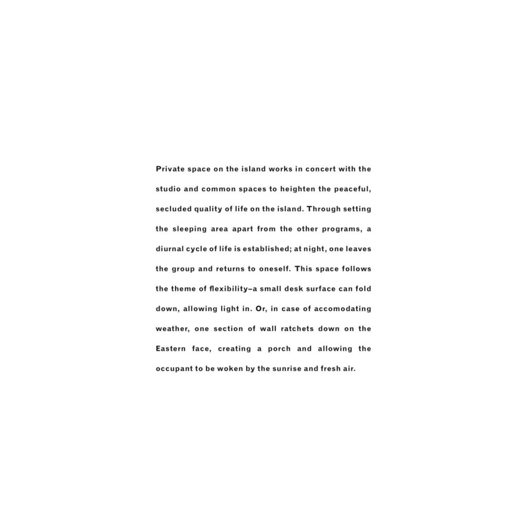
A short summary of each proposed structure is included with its visual description. With that in mind, it seems more appropriate here to merely include certain experiences that are ambitions of our designs:
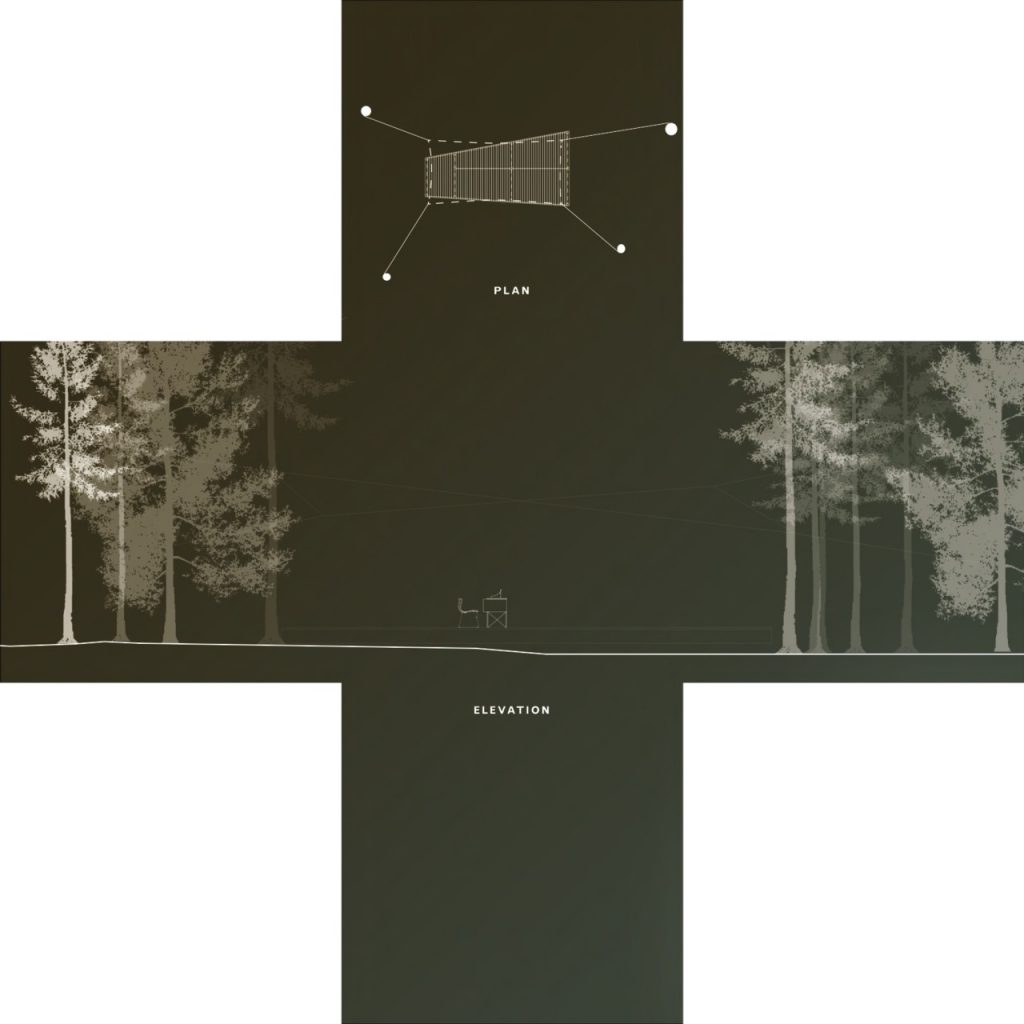
Laying the solar shower bags out on the Western rocks to be warmed by the sun over the course of a day; later, before an evening meal, a bag is hoisted with a rope to its place above the shower. The weight of the bag bends its metallic support, centering the flow of water above the light, wooden structure.
The gathering of people around a table for dinner under a canvas roof, open to the breeze, looking out over Lake Superior as the sun drops toward the water.
Painting a canvas while standing on a simple white plane, the byproduct of modernity, every glance away re-centering the painter within the natural sublime, a dense field of wood and light.
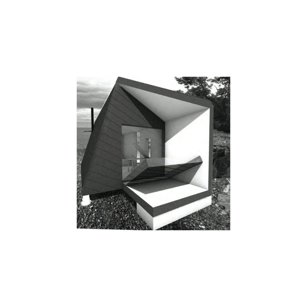
Returning through the woods to the sleeping quarters after a good day of work, ratcheting down the Eastern wall, then standing out on the surface it forms, watching the waves for a moment. In the morning, the sun floods this small room with light and color–-a vibrant but gentle alarm clock.
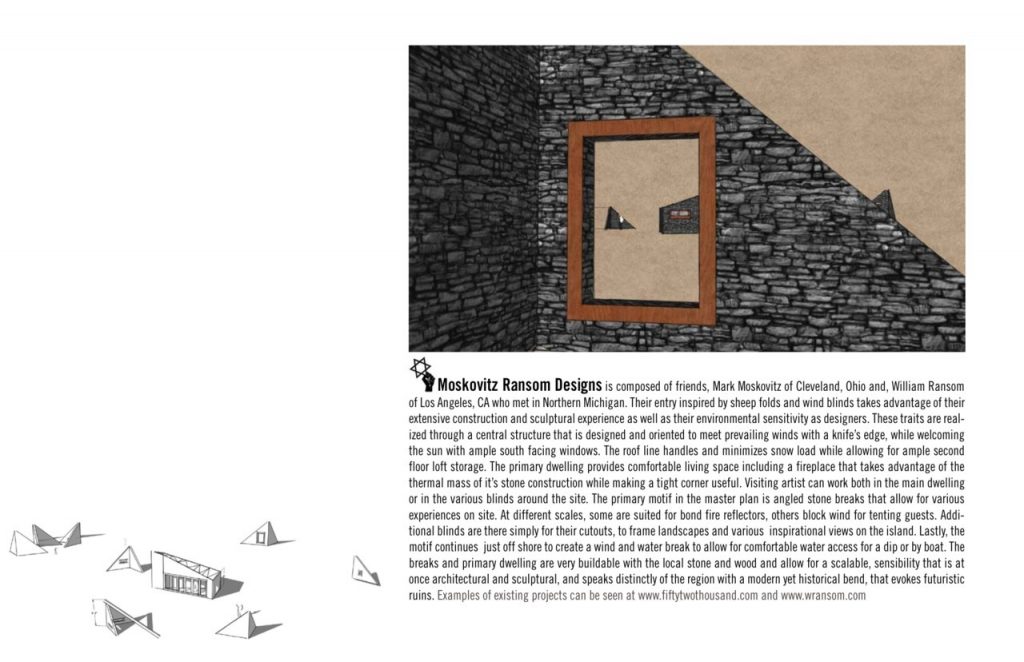
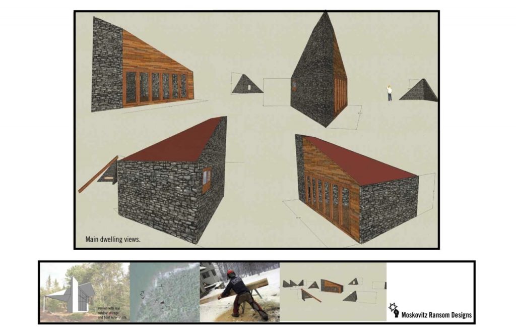
Rabbit Island Architecture Competition: Moskovitz Ransom Designs
Submission from Mark Moskovitz & William Ransom
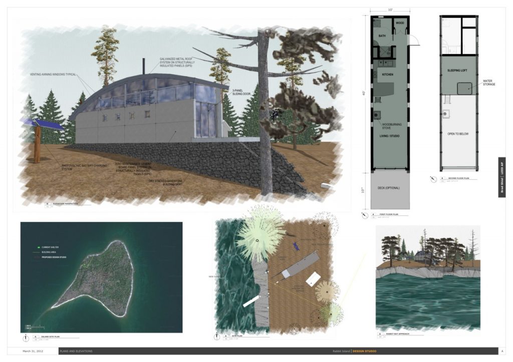
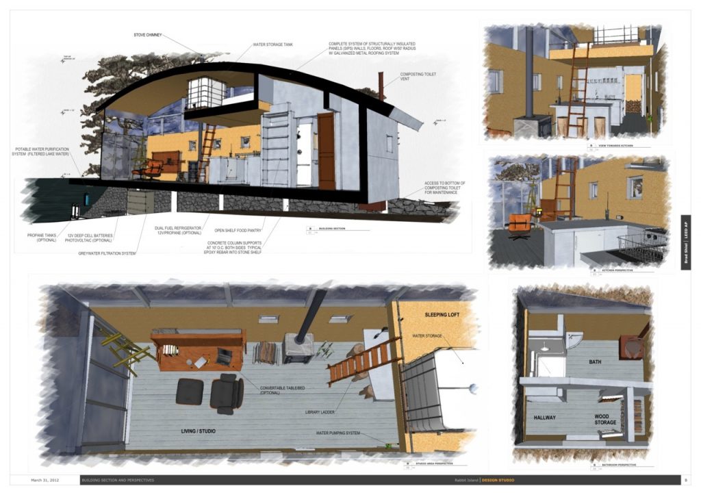
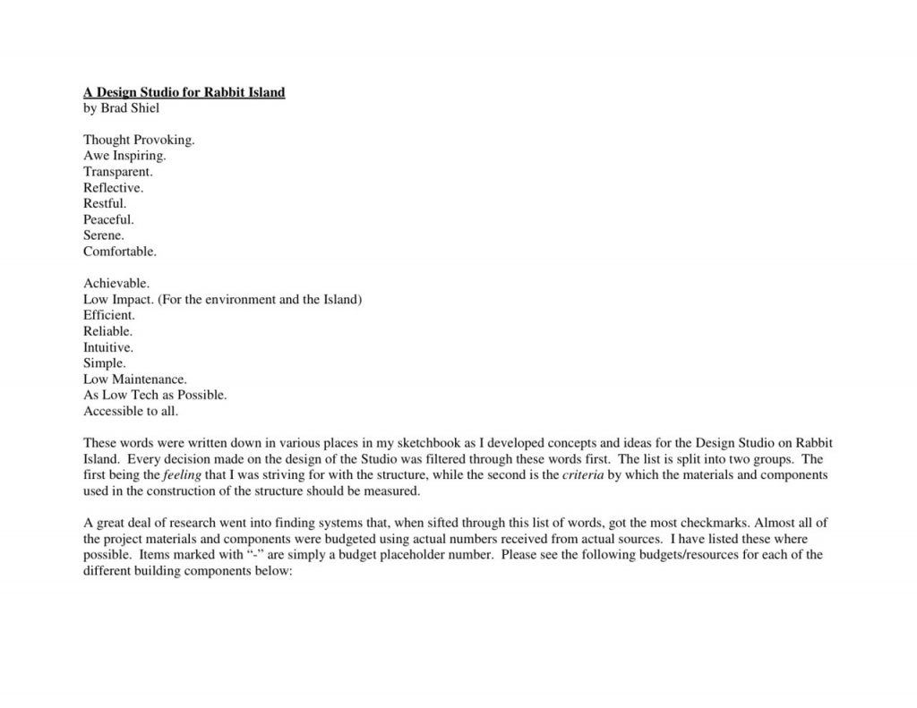
Rabbit Island Architecture Competition: Brad Shiel
Contact: bshiel@comcast.net
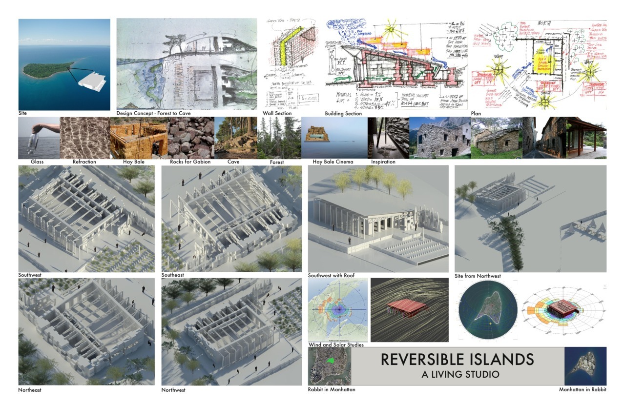
Rabbit Island Architecture Competition: Reversible Islands. A Living Studio.
Submitted by David Soka and Fisnik Rushiti, Madison, Wisconsin.
“And as the moon rose higher the inessential houses began to melt away until gradually I became aware of the old island here that flowered once for Dutch sailors’ eyes — a fresh, green breast of the new world.” Ch. 9, The Great Gatsby
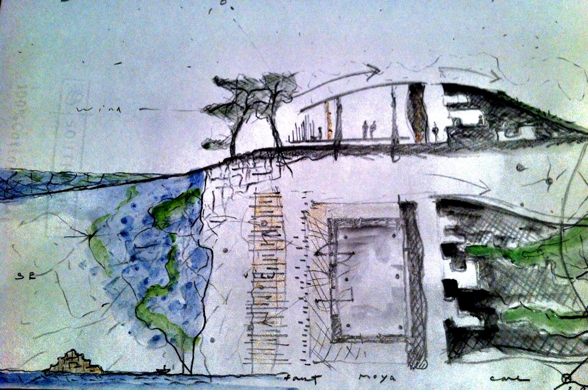
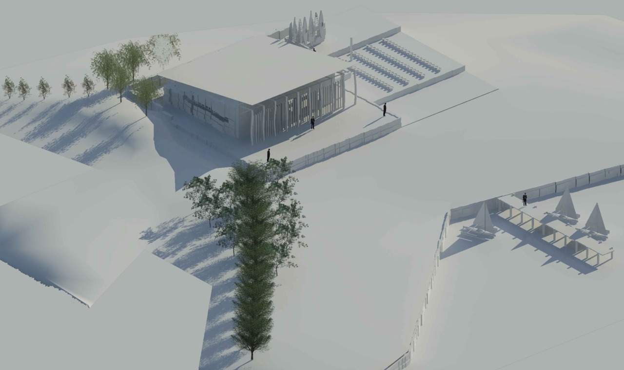
If we discovered Manhattan today as pristine wilderness, what would it look like? A small island in Lake Superior nicknamed Rabbit Island might give us the opportunity to go back in time. In Delirious New York, Rem Koolhaas describes Manhattan’s commissioner’s grid plan of 1811 as an “artificial domain planned for nonexistent clients in anticipation.“ Although the grid plan was visionary and successful beyond anyone’s wildest dreams, it could not be appropriate to overlay a grid on a virgin landscape and ignore its natural attributes today. If we are given the opportunity to build a small structure on such a magnificent island, it should begin with the notion of how we can begin to reverse the environmental damage that we have inflicted on our planet. This structure can ignite a conversation of how we should build in the 21st century and push the definition of sustainably to the next level. Initiatives such as The Living Building Challenge and The Natural Step can help guide us through this process. Much in the same way that the culinary world has embraced field to fork and locally sourced ingredients, architects are embracing critical regionalism. However, in the 21st century, ingredients can be local, but ideas are global and know no boundaries. The cathedrals in Europe and farmhouses in Japan were created by the labor of generations. The building of this structure can be a celebration of a global community of artists and artisans coming together to create something that in many ways should never be completed.
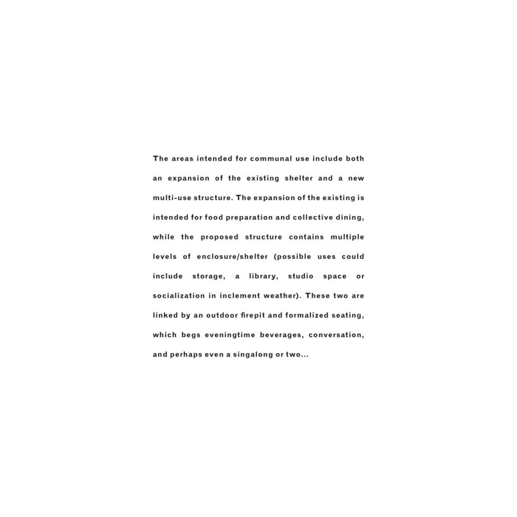
Reversible Islands, A Living Studio
Site: We propose locating the new studio just north of your existing cabin. Once the new studio nears completion, builders have the option to salvage materials from the existing cabin for the new studio.
Materiality and Concepts:
Forest to cave. Wood to stone. Impermanence to permanence.
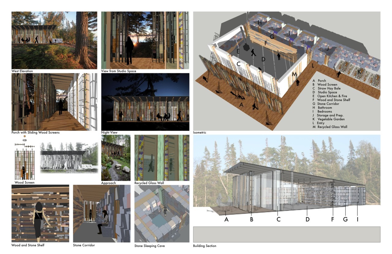
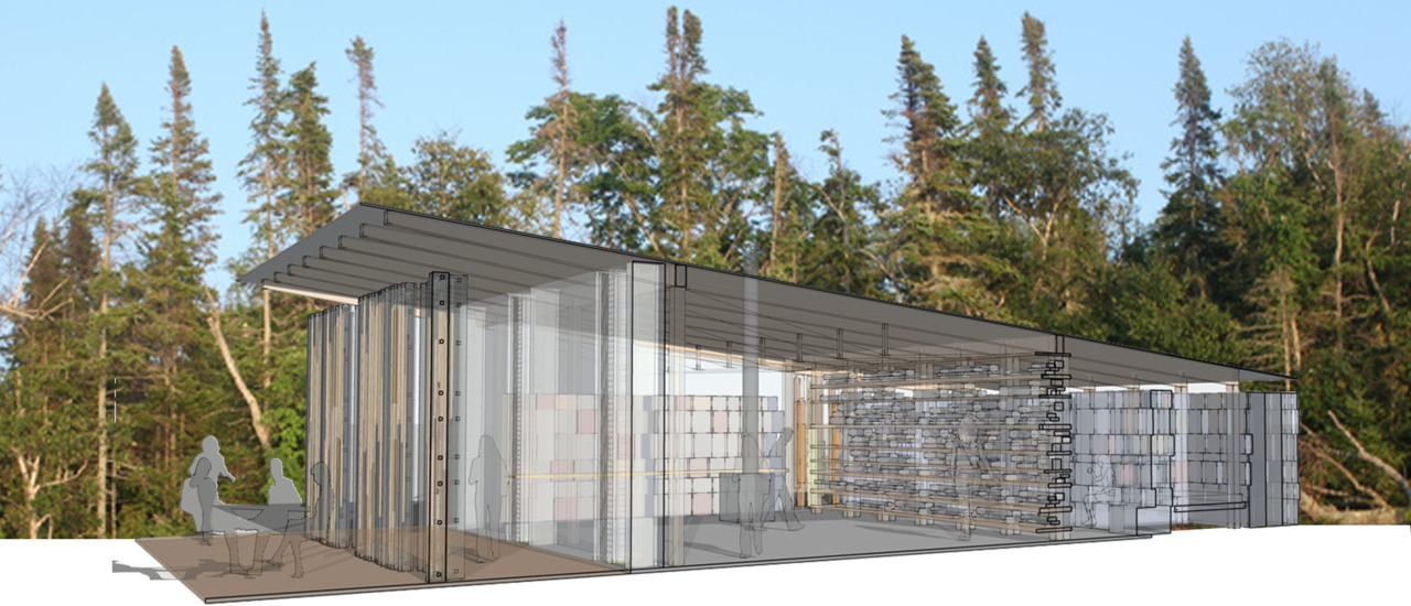
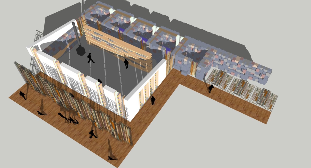
The studio is comprised primarily of materials harvested from the island. Any materials not from the island will be sourced as locally as possible. Components of the studio are listed below, letters corresponding to the isometric diagram.
A. Porch: When the sliding screen panels are closed, they will protect the interior porch (the space between the wood screen and hay bales) from wind and create dramatic shadows, similar to a forest floor. When the panels are open, they allow the full porch to be used as outdoor event and performance space.
B. Wood screen: The screen lets the low profile structure visually dissolve into the forest much like camouflage, and protect the structure from the harsh winds. Each screen panel will be constructed from one tree from the immediate forest. The screens are supported using conventional barn hardware and can slide in any position across the facade. Found objects can be woven into the structure like a bird’s nest. Visiting artists can reconfigure the patterns of the screen for their own creations.
C. Straw hay bale construction: Hay bales are an inexpensive, easy to handle material for constructing walls with insulation values up to R-50, depending on bale thickness. Hay bale construction is an ancient practice, repopularized on the American great plains after the invention of the mechanical hay baler. Hay bales will be transported from the nearest farm to the island on a large wood raft. The voyage on the raft can be an art event, with films projected on the surface of the stack of bales (see “Hay Bale Cinema”).
D. Studio space: The studio space is 40’ x 20’. This proportion allows for maximum flexibility and frontage to Lake Superior. The southern elevation of the studio will be constructed of recycled bottles and clear broken glass, allowing light to penetrate deep into the space during the long winters. The floor will be constructed from a combination of reclaimed lumber and stones from the site. Any existing bedrock outcroppings on site should be celebrated and allowed to protrude through the floor.
The roof structure is constructed of small-membered wood trusses. Unlike heavy wood beams, these light and flexible trusses come from more readily-available logs. The longest span is 22’ and can accommodate heavy snow loads. The shallow pitch allows snow to accumulate and provide extra insulation during the long winters. Artists can suspend objects from the roof trusses. Shingles will come from native stones.
E. Open kitchen & fireplace: The indoor kitchen has ample counter space along the north wall and easy access to the main studio space and the outdoors, allowing for flexibility during large dining events. Mobile kitchen and bartending units are available for outdoor events.
F. Wood and stone shelf: Symbolic of the water’s edge and rocky contours of Lake Superior, the shelf is a repository for books, objects of personal significance, and materials from the island. The wood and stone shelf also functions as a screen or filter between the studio space and the gabion sleeping caves.
G. Stone corridor: The space between the wood and stone shelf and gabion sleeping caves. Some of gabions will extend into the corridor for seats.
H. Bathroom: The experience of bathing in a space surrounded by stone will remind one of swimming in the caves along Lake Superior. The room will hold a deep bath, shower and sauna, with a composting toilet in an adjacent separate space.
I. Gabion sleeping caves (bedrooms): These are inspired by the small caves along the edge of Lake Superior. Since concrete is responsible for 8% of global CO2 production, we feel that no concrete should be used to connect stones together. Since the island offers a large supply of stone, we propose stacking stones in inexpensive, lightweight galvanized metal cages, creating gabions. The gabions can contain stones of various sizes and colors; it’s up to the individual builder how each gabion will appear. Since hay bales will act as the thermal barrier, the gabions can be constructed over several years. Each bedroom is 8'x8’, with beds suspended from the roof structure that can fold into the walls.
J. Storage and prep: The storage space will hold an electrical generator and tools. Prep space will hold tables for cleaning fish, butchering meat, and processing other foods.
K. Vegetable garden: Rainwater will be harvested from the roof and directed into the garden. The garden sits in a protected area within low stone gabion walls and is oriented towards the southwest.
L. Entry.
M. Recycled glass walls: The southern elevation of the studio will be constructed of recycled glass that symbolizes refracted light underwater. Recycled stacked glass, wine bottles, and clear broken glass reduces CO2 output of construction and embraces the imperfections of glass from old buildings and automobiles. The wine bottles that float to the island or enjoyed there can be added to the wall. To conserve energy, we recommended that no more than a quarter of the walls in the building are glass. Most will be on the south and west facades, to harvest sunlight.
David C. Soka, Architect: dsoka@flad.com
If he could, architect David Soka would live off of stones, woods, water and art alone. His favorite memories of growing up in the Hudson Valley are stacking stone walls with his father and working with his mother in her vegetable garden. As an undergrad at the University of Kentucky and an adjunct assistant professor at Ohio State University, David embraced the undulating landscape and farms of the lower Ohio valley. After completing a Masters of Architecture at Columbia University, David spent a year in Kyoto, Japan on a Keimeisha Fellowship. There, he studied traditional Japanese carpentry, painted watercolors of Zen gardens, collected grass for the roofs to be woven into the Kayabuki Minka, and developed a serious love of Japanese baths. David lived and worked in New York City for the following ten years at Edward Larrabee Barnes/ Lee Timchula Architects. In New York, he met artist Maureen Connor, and collaborated on an installation for Barcelona’s Antoni Tapies Foundation. David moved to Madison, Wisconsin in 2005, where he now designs sustainable university research buildings as a licensed architect and a LEED Accredited Professional at Flad Architects. David draws sustenance from rolling farmland, freshwater seas, and barn rafters of the Great Lakes, inspired by the environmental legacies of John Muir, Aldo Leopold, and Gaylord Nelson.
Fisnik Rushiti, Architect: fisnikrushi@gmail.com
The 21st century will force mankind into rethinking how we can inhabit nature without destroying it.
The elements that have defined the envelope of a building for thousands of years, the floor, walls and roof, continue to challenge architects. The act of building is about creating environmental, visual and emotional relationships between inside and outside. The urgency to conserve energy and create structures with minimal environmental impact moves all of us to be more innovative.
Fisnik Rushiti is passionate about these issues. After studying at The Technical University of Vienna under Finnish architect Kari Jormakka, he traveled extensively in Europe, drawing from naïve traditional architecture like many modernist architects of the 20th century. He has visited numerous villages and cities of western and eastern Europe, including Manarola, Positano, and Portofino in Italy and Dydima (Didim) and Kemer in Turkey.
For the past 15 years, Fisnik lived and worked in Madison, Wisconsin. At Flad Architects, Fisnik merges energy modeling and architecture, science and art, to help enhance the environment and human potential.
Rabbit Island Architecture Competition: Matthew Drury
Contact: ledessinatoire@gmail.com