
There is no Antonym for Subdivision
The english language does not have a fitting opposite the word subdivide, strangely. Combine, reconstitute, aggregate, multiply, unite and others come close, but none serve as antonyms in the context we use subdivision and none are closely related to economic principles underlying the way we subdivide. This nuance within our language signifies a subtle but very large cultural theme underlying almost everything else that we undertake as individuals and as a society. With the benefit of modern data aggregation and visualization it is clear that we have had many irrational blind spots in our historical land use patterns. How we arrived at the google satellite images of today from a native environment over only a few centuries is fascinating. Islands add relief to this idea by offering well-controlled exhibition within finite borders. Nantucket is a fine example of this. Land division is a complex issue that involving scales and timeframes larger and longer than the individual, and Nantucket’s historical experience to present, studied in retrospect, illustrates this complexity exceptionally well. Such history is helping inform a few "off island" conservation ideas we’ve been thinking about. (Rabbit Island itself, of course, will never be parcelized.)
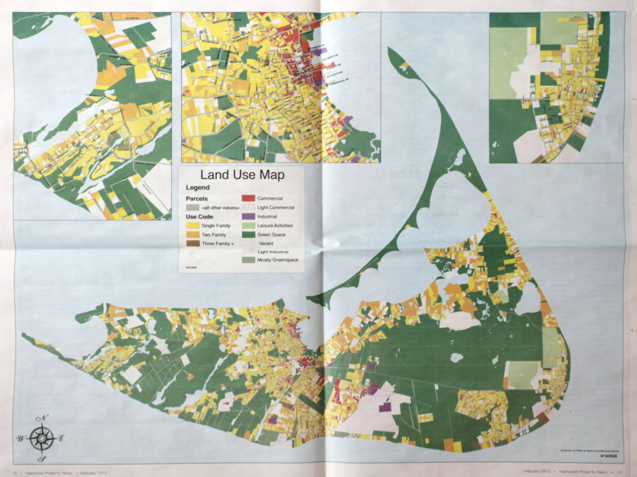
In 1659 Nantucket Island welcomes it’s first European settlers after being acquired from England by Thomas Mayhew. He promptly sells shares to nine associates for “ye Sume of thirty pounds in good merchantable pay in ye Massachussetts” and “also two Beaver Hatts, one for Myselfe and one for my Wife”. The whole thus suffers its first cuts. Over the next several generations this initial event evolves slowly into the parcel maps of Nantucket and the transaction itself becomes, perhaps, an enduring metaphor for the larger American settlement experience. Purchase, profit, divide, repeat… a way of life goes on an on, though never in reverse.
Nantucket, like America, progresses through stages of discovery and frontier settlement, develops a thriving economy via the utilization of natural resources (whaling), subdivides land into parcels based on an opportunity-driven market, enters a period of relative abandonment during post-industrial collapse, and then, (finally diverging from the mainland American experience), is rediscovered as a forgotten reservoir of accidental preservation resulting from nothing more than the simple absence of human economy. In the 1980’s this historical aberrancy is recognized in contrast to the mainland development experience prompting people (successful in mainland civilization, wealthy, with strong political standing) to consciously preserve as much remaining open space as possible–a full 320 years after the process began.
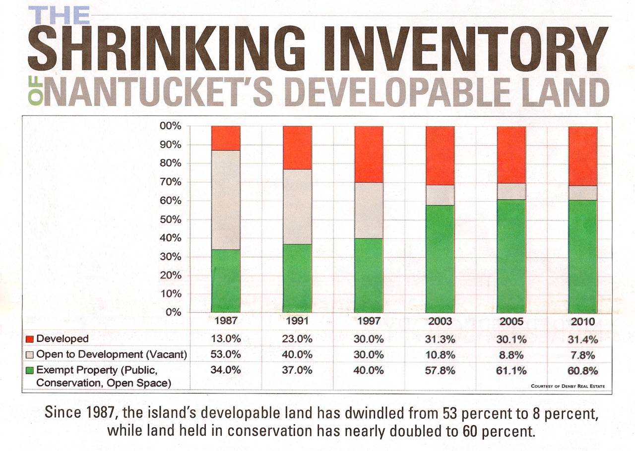
This effort is undertaken for the sake of posterity, of course, even if a bit late, and is for the most part successful. Today, however, the commodification of remaining developable land around conserved open space continues and new, ever-smaller lines in the plat book continue to be drawn. This change plods along so slowly as to hardly be perceptible from within the daily routine, but lots and parcels situated near preserved land (i.e. land removed from the normal economy) are continually marketed and cut into acres, portions of acres, units, timeshares… etc. This is facilitated, not without irony, using well designed infographics created by real estate publications (as above). And when observed in aggregate the charts and graphs above imply, of course, that once the area between the red and the green declines to zero percent, the amount of property available near open space will remain unchanged for a very long time–perhaps forever–and this is what we will be left with. Final lines are being drawn. Get yours while you still can. Prices only go up. Buy now. Supply will never change. The system will never move in reverse.
We protest this idea. The fact that subdivision happened and continues to happen with such binary imbalance in winner-take-all fashion, and that land is then taken off the table, is, on the fundamental level of principle, uncivilized. As it currently stands one of two things generally happens to land within the framework of our cultural practice: 1) conservation gets to a parcel of land first and locks it in, or, 2) subdivision gets first crack and development progresses without regard for collective ideas and smaller units of land are ever-passed to successive generations. The larger picture on the map only becomes more polarized as time horizons are extrapolated further into the future. This binary historical example has obvious limitations that are in conflict with contemporary understanding. In a civilization that no longer has the luxury of new frontier it is only logical that recycling of existing land, in a manner consistent with reason and scientific advance, becomes a basic requirement for maintaining quality of life. Yet thus far in our history this has not been conceived on an organized scale. It doesn’t even appear to be part of any serious conversation. Our society’s founding documents and legal precedents were, after all, conceived in a time flush with frontier. Foresight apparently has its limits.
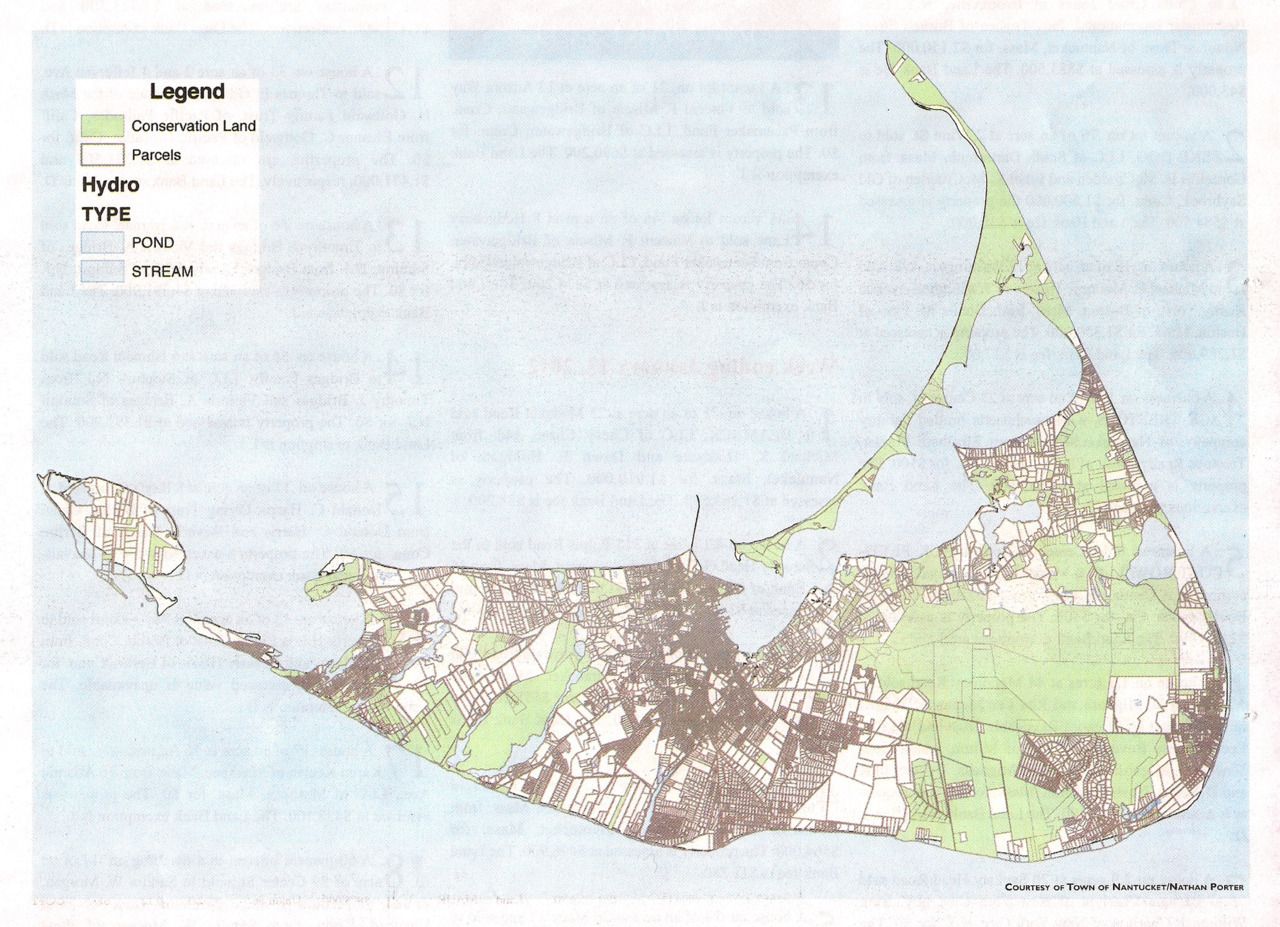
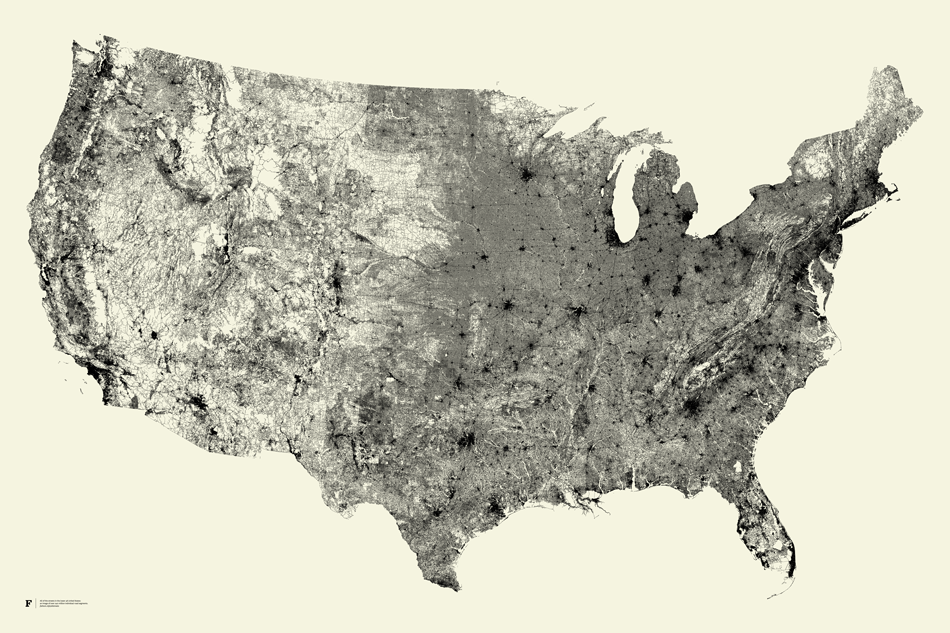
When the message of Nantucket’s maps are extrapolated to our entire country (an arbitrary island of larger size), it is clear that very little opportunity for parcelization and road access has been missed and open space has suffered a death by a thousand cuts, leaving only remnants of land and watersheds without disruption. When empiric numbers are studied mainland ratios of developed to undeveloped land look very different from Nantucket, and certainly not for the better. Development has most certainly won a lopsided victory over conservation in the binary historical experience. Only about 30% of American land is set aside in programs for the public intended to retain or celebrate broad stretches of natural function, and of this allotment the vast majority is unevenly distributed in western states and Alaska, and, more specifically, concentrated in areas of uneven terrain (mountains), areas containing an excess of water (everglades), areas without enough water (deserts), or regions having inclement weather patterns (far northern latitudes). If you scroll across the country (or fly from New York to LA on a plane) it becomes evident that there is not a single area of ecologically important scale that does not fall under one of these categories that has been given pardon from development.
As a result “locavorism” with respect to visiting intact natural ecosystems is not possible for the majority of the population in our country and a divide is formed whereby cultural institutions benefit primarily those proximate to urban civilization while intact wilderness areas, northern forests, southern swamps and southwestern deserts serve mainly the relatively light population density surrounding them. In very few places do the two ideas exist reasonably adjacent to one another and almost nowhere has nature been celebrated simply because it is nature without a caveat. Rabbit Island, of course, claims “cold winter” for avoiding historical development, though the fact that it was given reprieve at all at this point in history is amazing.
Empirically the evidence of land division is striking and what has been lost in most places east of the Rockies or in states without long winters is profound: anything involving systems, ideas, or populations that cross individual property lines, migrations, salmon runs, climax forest communities, apex predators, clean rivers, expansive views, dark night skies and stars, the fundamental experience of uninterrupted nature, etc. Certainly we value these things and our heritage is founded on them, yet, peculiarly, there is no organized mechanism to un-divide land hundreds of years after we started cutting it up. Why is this? This is a big question for society and perhaps–and in all seriousness–on par with the big questions of previous generations: Why were women not allowed to vote? Why were unions allowed when before there were none? Why was Medicare created? Why were African American children and White children assigned different schools? In hindsight it appears absurd that there were times when such disparities existed. So too does it seem absurd that society has no way to un-divide on an ecological scale baked in to its founding principles. There is no organized mechanism intended to give people reasonable access to the fundamental instruction that nature provides. Will the next several hundred years of American experience witness a continuation of the historical example of subdivision or will the pendulum swing in a new direction given our collective understanding that now spans from DNA to Google Earth? It seems an obvious inference to suggest that something must give. This is not to say that civilization should move in reverse or that technology should be shunned, but simply that it would be an advancement if nature and the urban environment were organized more rationally so as to maintain a more whole spectrum of experience, including the untouched, the gridded, and everything in between–on a more local level. A mechanism for this does not exist.
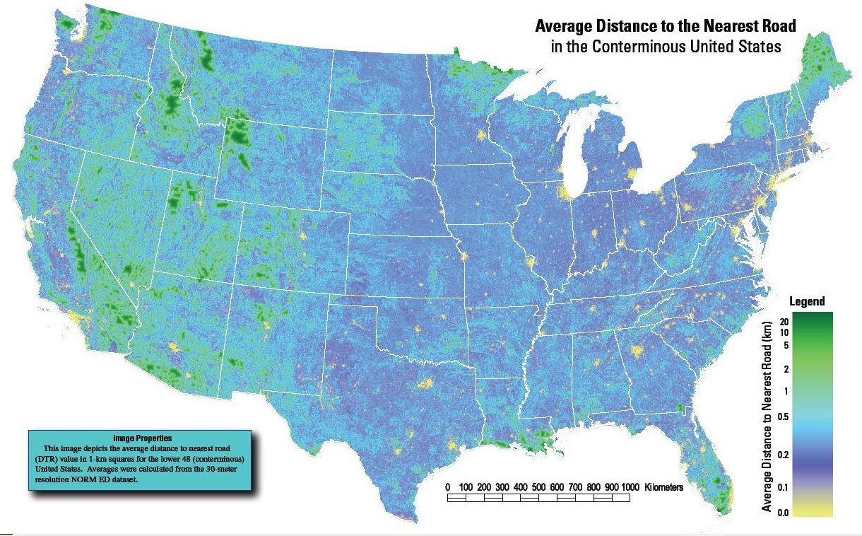
Below is an abstract from the journal Science on the subject of subdivision from a perspective of road building. Road building–the most physically impermeable and historically irreversible of all municipal ventures in land use–is inextricably linked to subdivision and could even serve as a synonym for ecologic subdivision in empiric terms. The authors here, protesting the status quo, define a new metric, “roadless volume”, which is a novel idea. It is easy to see the effects of roads on native ecosystems by driving around a bit, yet quantifiable data illustrating this would be useful for an organized effort to reorganize previously subdivided land based on the thesis that open spaces scaled to population centers have societal value and that this value has been under-recognized historically. Our predecessors have subdivided relentlessly and our system is set-up only to continue this. Apart from the few sparks of genius and foresight and political will that popped up along the way as we moved westward the maps above illustrate the unintended consequence of our development heritage. It is striking in aggregate.
One of our Rabbit Island “off island” projects will experiment with these ideas using new models–part Nature Conservancy, part Kickstarter, part Google Map, part B Corp, part Votizen. If you want to get involved or if you have experience with mapping, data, design, web engineering, lobbying or other relevant skills, please get in touch. Meetings will be held in New York (and on Rabbit Island on occasion), though virtual collaboration is possible from anywhere.
Contact: rob@rabbitisland.org
Science, 4 May 2007: Vol. 316 no. 5825 pp. 736-738.
Roads encroaching into undeveloped areas generally degrade ecological and watershed conditions and simultaneously provide access to natural resources, land parcels for development, and recreation. A metric of roadless space is needed for monitoring the balance between these ecological costs and societal benefits. We introduce a metric, roadless volume (RV), which is derived from the calculated distance to the nearest road. RV is useful and integrable over scales ranging from local to national. The 2.1 million cubic kilometers of RV in the conterminous United States are distributed with extreme inhomogeneity among its counties.